Blog 33 23/05/2016 Piri Reis: Ottoman Admiral and Cartographer.
Piri Reis: Ottoman Admiral and Cartographer.

In 1929, a small section of a world map was discovered at the Topkapi Museum in Istanbul. This wasn’t just any map but the oldest known Turkish atlas showing the New World and one of the oldest maps of America still in existence anywhere (the oldest is the one drawn by Juan de la Cosa in 1500). The cartographer responsible for this remarkable piece of work was Haci Ahmed Muhiddin Piri (1465/70 – 1553) better known as Piri Reis (“Reis” being the Turkish equivalent to a naval commander or Admiral).This map was made in 1513 and was compiled from information gathered from military intelligence and maps of Christopher Columbus, (who spent some time on the Island of Chios and who would have been well acquainted with the various naval commanders of the day), and Arab, Indian and Portuguese sources. It was drawn on gazelle skin. Due to the fact that a small section of the corner is missing its size is estimated to be between 90 x 60 cms to 86 x 62 cms. It was presented to Sultan Selim I in 1517. A second World Map was drawn in 1528 of which only a small fragment survives.

Piri Reis’ World Map showing the coast of North America.
The exploits of Piri Reis (known in Turkey as Taner Alakuş), slipped into obscurity until Ottoman archives recently uncovered more about the identity of this man who was one of the most important Admirals of his day. Piri is thought to have either been born in Gelibolu (Gallipoli) in present day Eastern Thrace, or in Karaman, one hundred kilometres south of Konya in Anatolia. His father’s name was Haci Mehmed Piri and the presence of the honorary title of “Haci”, indicates that both father and son had completed the Hajj to Mecca. In 1481, Piri followed in his Uncle Kemal Reis’ footsteps for a life on the high seas. The 15th and 16th centuries were the heady days of privateering and fortunes could be made and lost in the service of the Empire, and both Christians and Muslims alike participated to serve their respective countries – and of course, themselves. Kemal Reis was just one of these well-known privateers (corsair) and he later became a famous Admiral in the Ottoman Navy. Together with his uncle, Piri took part in many Ottoman naval battles against Spain, the Republics of Genoa and Venice, including the First Battle of Lepanto in 1499 and a Second Battle of Lepanto a year later. After his uncle died when his ship was wrecked in a storm as he was heading to Egypt, Piri returned to Gelibolu to study navigation.

Suleiman the Magnificent
By 1516, he had risen to the rank of ship’s captain in the Ottoman fleet and took part in the conquest of Egypt. Six years later, he took part in the siege of Rhodes against the Knights of St John which ultimately led to Rhodes surrendering to the Ottomans on 25 December, 1522. Twenty-five years later, Piri had risen to the rank of Admiral as the Commander of the Ottoman Fleet in the Indian Ocean and Admiral of the Fleet in Egypt. This was the period of Ottoman expansion and a great deal of Piri Reis’ activities was spent out-maneuvering the Portuguese, particularly in the Persian Gulf as they made their way to India and the East. Today, Piri Reis is most remembered for his lifetime achievement known as the Kitab-i-Bahriye or Book of the Navy, now more commonly known as The Book of Navigation, one of the most famous cartographic works of the period. It was first published in 1521 and was revised four years later with better-executed charts and additional information and was presented as a gift to Suleiman I. The revised edition has a total of 434 pages containing 290 maps. At the time, they were considered to be a comprehensive representation of the known world of his era. Importantly, they include the recently explored areas of Africa and America. What makes these maps so important is that he pulled together all known maps at the time including those of Christopher Columbus. On his first world map of 1513, he writes “these lands and islands are drawn from the map of Columbus” and in another, he writes “maps drawn from the time of Alexander the Great” although it was later thought that he mistakenly confused the 2nd century Greek geographer, Ptolemy, with Alexander’s General. He also utilized many of the Portuguese maps of the period including those of Vasco de Gama.

Map of Venice
When I first saw the maps in the Kitab i Bahirye, I was particularly drawn to colours and the added details and lively designs that accompany the outline of the coastline. He was a consummate cartographer and not an explorer but he recognized the importance of pulling together all the various sources available to him in this one comprehensive book – techniques of navigation-related information combined with astronomy, geography, information about the local people of each country and culture. For anyone unfamiliar with the places, it’s possible to get a feel through the illustrations alone. Great care has been taken to draw buildings and public spaces – mosques, churches, public monuments, bridges and flora which bring the places alive. His use of colours, in particular the accents of gold, are reminiscent of medieval manuscripts. I particularly like the decorative, almost plaited treatment of the various mountain ranges and his depictions of the palm trees that filter out into the desert such as those portrayed in the map of the Nile Estuary. The legends surrounding the maps are written in Ottoman Turkish with one in Arabic.

Map of the River Nile Estuary with the Cities of Rashid and Burullus on each side
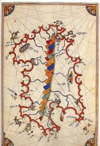
Map of Sardinia showing the central mountain range

Map of Egypt
The Kitab-i-Bahriye has two main sections. The first is dedicated to information about techniques of using a compass, portalan charts and the various types of storms, etc and the second is composed of portan charts and cruise guides. Each topic contains the map of a specific island or coastline such as the Straits of the Dardenelles, Anatolia, the Aegean Sea, the Ligurian Sea, the French Riviera, Spain and North Africa as well as the Nile Delta and the Levant. Interestingly, there are no maps of the Black Sea region. They were added in the middle of the 17th century when a third version of his book was produced that included additional information based on Dutch and Italian works of the previous century.

Map of the Coast of Andalusia with the city of Grenada
It may be that one of the reasons for Piri Reis’ demise into relative obscurity was due in part to the situation he found himself in during the last couple of years of his life. He was almost ninety years old when he returned to Egypt but quickly fell out of favour after refusing to support the governor of Basra, Kubad Pasha, in another campaign against the Portuguese and was beheaded in 1552 – an ignoble end for someone who had devoted his life to the service of the Empire. Today his legacy lives on in the numerous battleships and submarines of the Turkish Navy that have been named in his honour.
Copies of the Kitab–i-Bahriye can be found not only in Istanbul but in other great libraries around the world – Vienna, Bologna, Dresden, Paris, London, Oxford and Baltimore.
“The Embroiderer”

“The Embroiderer” is a beautifully written novel spanning the 19th and 20th centuries, set against the backdrop of the Greek War of Independence. It was published on 5th November 2014 and is available to buy in paperback and as an ebook.
http://www.amazon.com/s/ref=nb_sb_noss_2?url=search-alias%3Dstripbooks&field-keywords=The+Embroiderer+


0 Comments
Trackbacks/Pingbacks